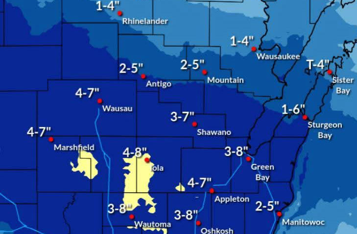
3 PM {12/9/2025}
There has been a small southwards shift in the overall snowfall for tonight, but many of the other details remain the same.
Overall, the National.Weather Service in Green Bay is expecting a broad area of 4-6 inches of snowfall in the Fox Valley.
Somewhere within that band will be a more focused higher snow total pushing closer to 7 inches.
As a result you’ll see the upper range showing 7-8 inches across central and portions of east-central Wisconsin, but only a smaller subset of the region will see this higher end.
Timing for the heaviest snow remains around 7 p.m. to midnight for central Wisconsin and 9 p.m. to 3 a.m. for areas in east-central Wisconsin.
Some light snow may linger on into Wednesday morning.
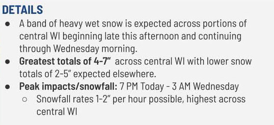
5 AM {12/9/2025}
A round of heavier snow arrives later Tuesday and continues into Wednesday morning, according to the National Weather Service in Green Bay.
Peak snowfall begins about 7 p.m.
A band of heavy snow is forecast across northeast Wisconsin with 4-7” of wet snow expected.
Most other locations can expect 2-5” of snow, with locally higher amounts possible into east-central Wisconsin.
A Winter Storm Warning has beem issued for most of central and parts of Northeast Wisconsin in effect from 5 p.m. Tuesday to 6 a.m. Wednesday.